
Компания Аэрострим предлагает сервис по мониторингу изменений на открытых горных выработках и карьерах с использованием инновационных технологий применения беспилотных летательных аппаратов и последних достижений в области обработки данных и компьютерного зрения.
Примеры работ по съемке и построению 3d моделей карьеров
Мы предлагаем:
- Создание трехмерных моделей карьеров, отвалов, выемок, насыпей
с точностью до 5 см в плане и по высоте. Модель включает цифровую модель местности и ортофотоплан высокого разрешения - Расчет объемов насыпей , выемок, отвалов
технология позволяет вычислить объемы спустя несколько часов после вылета и опубликовать данные на WEB сервисе - Вычисление разницы объемов насыпей
при периодическом мониторинге вычисление разницы объемов насыпей, выемок, отвалов в режиме «было/стало» за отчетный период - Публикация данных на WEB-сервисе
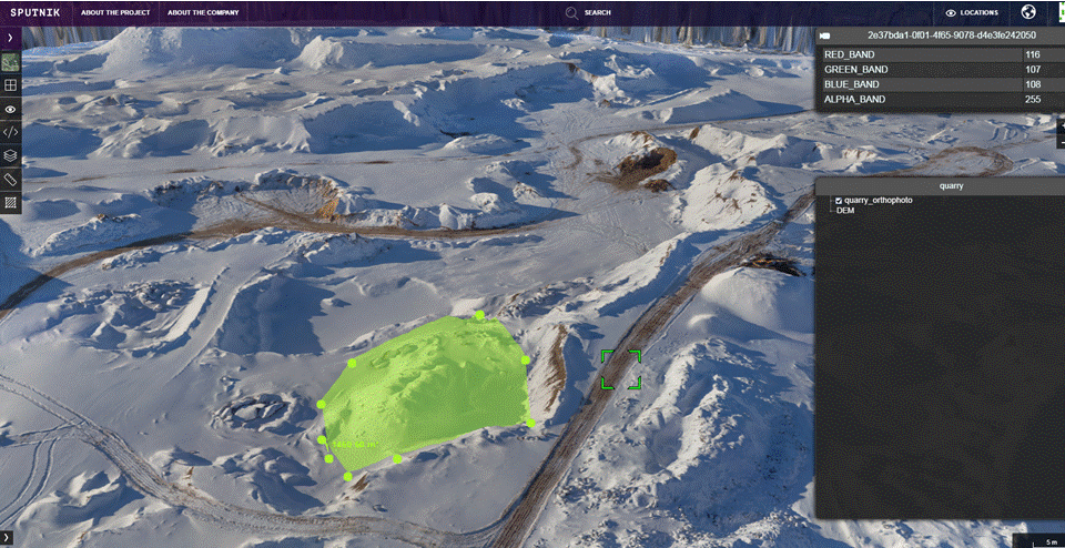
мониторинга изменений с визуализацией на картографической основе 3D модели карьера с выводом показателей изменений объемов за выбранный период времени - Определение фактических границ участка
мониторинга изменений с визуализацией на картографической основе 3D модели карьера с выводом показателей изменений объемов за выбранный период времени - Аэровизуальный мониторинг территории
с передачей изображения HD качества
Как это работает:
1. Производится съемка с заданной периодичностью
По результатам строятся 3D модели карьеров
Модель включает цифровую модель местности и ортофотоплан высокого разрешения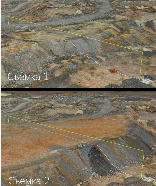
2. При выполнении двух и более съемок по моделям вычисляется разница объемов насыпей, выемок и отвалов в режиме «было/стало» за отсчетный период.
При наличии одной съемки объемы считаются от отсчетной поверхности.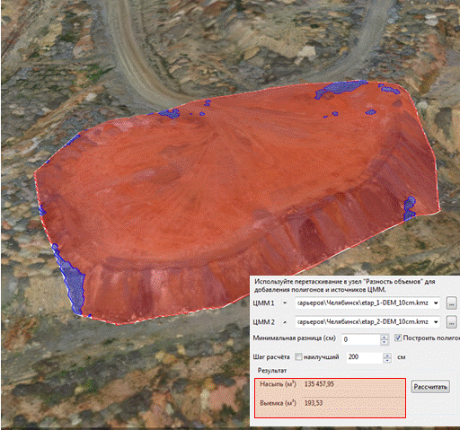
3. Данные могут быть опубликованы на WEB-сервисе в виде слоев за каждую дату по закрытой ссылке и просмотрены с любого рабочего места.
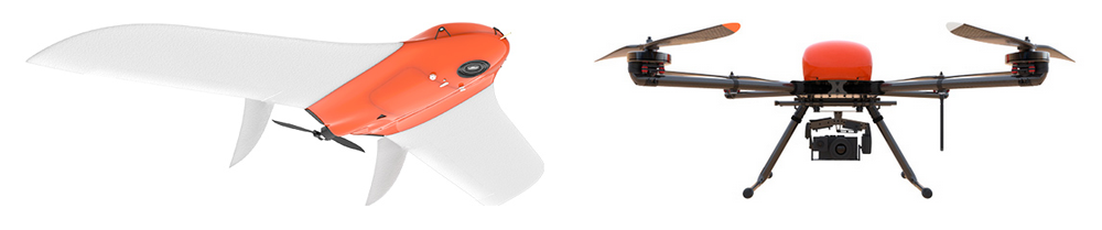
Съемка производится с помощью промышленных дронов
Съемка производится с помощью промышленных дронов в автоматическом режиме под контролем оператора. Высокое качество модели достигается за счет использования профессиональной камеры на борту (Sony RX-1) и точной синхронизации между фотоаппаратом и бортовым gps-приемником. Компания Аэрострим в своей работе использует технологии ведущего отечественного разработчика — компании Геоскан и собственные разработки
В основе технологии лежит создание высокоточной 3D модели поверхности карьера (горной выработки) по данным съемки с БПЛА и данным ГНСС оборудования. Цифровая модель поверхности, построенная с использованием беспилотных технологий, геометрически точнее, чем модель, полученная традиционными наземными методами.
Экономическая эффективность достигается за счет высокой скорости получения данных с точностью близкой к данным лазерного сканирования, сокращения затрат на полевые и камеральные работы, исключения человеческого фактора при выполнении измерений и расчетов.
Обработка может быть произведена прямо на месте, либо через удаленный веб-сервис.
Пример трехмерной модели карьера
(лев. кн. мыши: перемещение, пр. кн. мыши: изменение угла, колесико мыши: увеличение/уменьшение масштаба)

